Online research tools to find gold
How to find gold by doing some online area research. In this post, I’m going to outline the steps I use to research areas to find gold. By following the steps in this guide you can locate areas that may lead to some high grade gold ore. This is an example of original online research. I’ve never been to or even heard of the following area before today.
Step 1. Google books
I like central and northern Nevada. Extremely remote, with a past (and current) gold production history. I sometimes start with a plain old google search, but today I did a google book search. You can try any search that interests you. For example: “placer gold Arizona” or maybe “Nevada mining districts”, etc. Today I did a search for: “gold deposits of Nevada”, quite a few interesting links came up. One that caught my eye was: Gold Deposits of Slumbering Hills, Nevada.
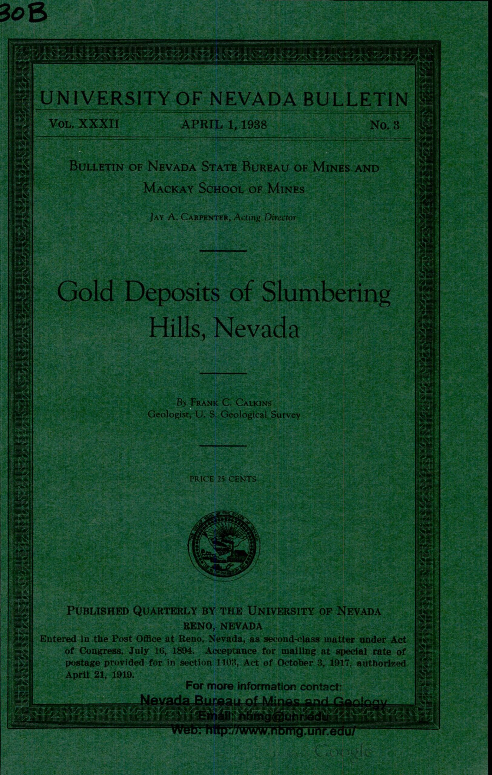
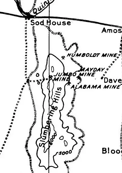
The bulletin from 1938 by The University of Nevada, Mackay School of Mines, and The Nevada Bureau of Mines cover area geology, the names of past and current gold mines, types of gold deposits, ore geology, and even where the gold was deposited within the ore bodies. One or two paragraphs caught my eye, with one describing a highly oxidized 8” wide oreshoot within the Alabama mine that assayed at 86 ounces of gold per ton.
If we need them later we now have more localized search terms from the bulletin too.
Slumbering Hills, Nevada (I would try the following search phrases both with and without Nevada in them)
More search phrases:
- Amos mining district
- Awakening mining district
- Jumbo mine
- Alabama mine
- Humboldt mine
- Mayday mine
- Jungo mines
(and lots more, including a 1938 listing of Mackay School of Mines publications covering some other areas in Nevada).
Mining and Geologic reports
Keep in mind there are many different sources of mining reports, the USGS, State, and Federal mining bureaus, etc. I will post a future article listing the various sources of mining and geologic reports by state, including links to report archives (usually universities) for agencies that are no longer in operation.
Step 2. Google Earth
Using Google Earth to spot mining activity
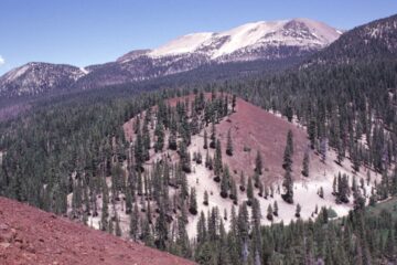
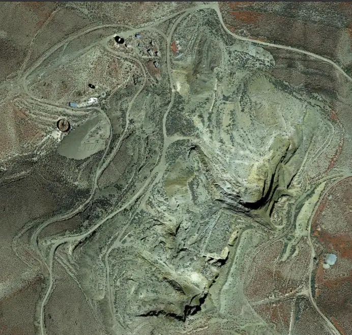
Before I get too involved with document research, I take a quick flight to Slumbering Hills onboard Google Earth. Sure enough, a search takes me right over the small mountain range’s high point. The 1938 Slumbering Hills bulletin included a topo map showing the approximate location of some of the area mines. By using both that topo and google earth i soon pin down what i believe to be the Jumbo mine. Remains of a mill, outbuildings, tailings and a huge “glory hole” carved into the west side of the ridge, and 2 or 3 miles west I find evidence of more modern workings. I’ll find out more about that later. Now I need to check the area’s “land status”.
Step 3. BLM National Data Viewer
Overview of the BLM National Data viewer
Checking Land Status
This viewer can be a bit tricky at first, but it’s much faster than in years past. The ArcGIS platform is much improved as far as loading times go. I’m going to be looking for BLM lands that are “open to location”. Meaning, basically, areas where it is legal to prospect for gold and locate mining claims. BLM land is shown in yellow. Forest Service in light green (most FS lands are open to location, although some may have additional reg’s). Private lands are shown in white, or clear if you have satellite imagery toggled on as your base map layer.
Layers and Land Designations
The layer menu at the right side of the viewer only needs two boxes checked for my needs here, the 8th and 9th. Checking them will ensure National Monuments, Wilderness areas and similarly designated lands will show in the viewer. Those lands are obviously “closed to location”, as are National Parks, military lands, and Native American reservation lands, and others, some of which are shown by default. If in doubt, just click on any area and a popup will tell you the land designation.
Just like any map data, there may be errors or omissions. A phone call to the BLM field office overseeing your area of interest might be a good idea at some point in your research.
Metadata
Notice at the top of the viewer screen where it says “Metadata and Downloadable Data”? See my post: How to use Google Earth as a Prospecting Research Tool, where I go over in detail how to import and use different types of georeferenced maps and metadata in Google Earth Pro. They will fine-tune your research, but for now, the BLM viewer will give me what I need for my preliminary work.
Using the BLM National Data Viewer
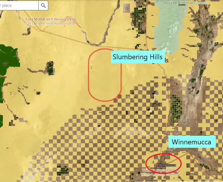
As I zoom into the Slumbering Hills which is about 25 miles northwest of Winnemucca, Nevada. I see that the entire area that interests me appears to be open BLM land. The checkerboard pattern to the south is a square mile grid and a mix of BLM and private land. The South Jackson Mountains Wilderness is in dark green at the far left, and the Humboldt National Forest at the top right in light green. Alright, everything looks good so far…onto the next step and the moment of truth.
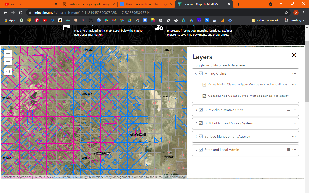
Step 4. BLM Mineral and Land Records System (MLRS)
I say the moment of truth because the MLRS viewer is going to show me if there are active mining claims in the Slumbering Hills. By active I mean valid, current mining claims. There may be no activity at all, in fact, mines in the area may seem abandoned, but that doesn’t mean they’re not “active” claims.
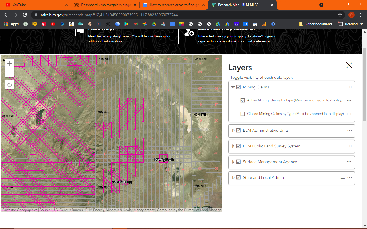
Researching active and closed mining claims
As you can see above, the Slumbering Hills is covered with active mining claims. Pink indicates active mining claims. When I saw the evidence of more recent mining on google earth earlier, I thought this might be the case. All is not lost though.
Notice the open areas between the groups of pink grids. By toggling the layer menu on, at the bottom right of the screen and checking the “closed” mining claim box, I can see those open areas, at one time, were active claims. Now closed and shown in blue.
More research needed
Further research is needed, but theoretically, those open areas can be explored and prospected. They may not be of interest, geologically speaking, to the larger mining companies and exploration outfits, but may (or may not) contain small, high grade ore veins or stringers.
Some of those hills and washes may also contain gold that has been eroded from the enclosing rock and might be a good place for a drywasher or gold detector.
The 1872 mining laws say that if you are a prospector, you can legally cross over active mining claims, to gain access to areas that are open to location. Just tread lightly though, as an irate cattle rancher or mining caretaker may not agree. If you have to pass through an open gate, leave it open. If it’s closed, close it behind you. And, of course, always be mindful of no trespassing signs.
Again, further research is needed, but the Humboldt mine as shown on the topo map under Step 2 above, may just be in the clear of the active mining claim area. There is a lot of information available about the Slumbering Hills: historic placer mining records, modern mining projects, you name it. You are only limited by how much effort you want to put into research.
Sleeper
I did a bit more looking on google and found reference to the more modern mining venture in Slumbering Hills, a mining database out of Australia called PorterGeo. I’ve used it before. They are very good at consolidating information from various sources. The newer mine was called Sleeper. Someone had a sense of humor, right? Slumbering Hills, Awakening mining district, Sleeper mine.
Bonanza ore
They reference three types of ore deposits at the Sleeper. The one that gets my attention is the “Bonanza type, low sulfidation, epithermal deposit”. Meaning basically, that it was: a very high grade, free milling, shallow deposit.
PorterGeo also tells me that gold values in the bonanza ores at the Sleeper ran as high as 6700 grams per ton. That’s a LOT of ounces, let me see… 215 ounces per ton. The average was more on the order of 2 to 3 ounces per ton, although I’m sure there were some amazing pockets uncovered. See How to Find Gold – High Grade Gold Ore for more on Bonanza-type ores.
As far as I can tell the Sleeper mine ceased production in 1989 after processing several million tons of ore, in return for several tons of gold. Interest in the area remains high, as evidenced by the active claims. The area interests me, that’s for sure. I’m definitely going to add Slumbering Hills to my list of areas to explore.
So, the above four steps took me less than an hour to complete. I went from knowing absolutely nothing about Slumbering Hills, to gaining quite a bit of knowledge of the area.
Step 5. Historic newspapers
I can definitely drill down further into the area’s history and geology to gain even more insight. The Library of Congress has an amazing archive of old newspapers called Chronicling America,
Free to use. you can search phrases by state. For example, i check Nevada and search for Slumbering Hills. My search comes back with 31 articles, starting in 1911. I look at a few and find them all to be mining-related. What a cool research tool.
The coolest part of all this research is the ability to gather data from the comfort of home. And it’s all free. It’s amazing to me what’s available online if you know where to look and what to look for. There are literally hundreds, if not thousands of areas to research across the western USA.